Snapshots of LoveYourBigMuddy Expedition

My dear friend, supporter and river brother from Columbia, Missouri, Jonathan Lauten, produced this slide show of my trip thus far. It is very special to me as the memories provoked are fond and special. I think it is kind of funny that the slideshow brings back so many memories of a trip of which I am still in the midst.

Please take a moment to enjoy these very unique and special moments from LoveYourBigMuddy Expedition 2013.

I will try to continue my documentation of my expedition on this blog as soon as I am able, likely as soon as I get across Lake Oahe, of which I am over half way on this 230 mile lake (as of July 25, 2013).

Click on the photo below to access the slideshow.  Thanks for your support!  -Janet

RAINBOWCAMP

https://www.facebook.com/photo.php?v=619718804729649

More Ski Videos in Hell Roaring Canyon: The Faceplant and The Bivy

We were getting tired by the afternoon and frustrated with the terrain traps we encountered, which kept adding miles on to our trip. Here is a short clip Norm took after my, umm, classic faceplant.

Shortly after the faceplant, we realized we were not going to make it out. Fortunately, our walkie-talkies were able to reach Haley and Jeannie just for a moment, and we notified them we would be staying overnight. We tried not to seem alarmed so they would not worry. That worked. We did the same for ourselves, and just tried to make the best of the situation.

A source start means a snow start, but ice-covered lakes?

ViewFromSouthValleyRoadSnow_112142
View of Lower Red Rock Lake in February. The lake is frozen over and looks like one large flat meadow.

Based on my camping experience in Missouri, I know that the threat of cold weather is present in mid-Missouri until AT LEAST after Mother’s Day, which is usually end of May (last hard frost date is late April).  So, starting my trip in mid-April in the Montana Centennial Mountains at the Continental Divide pretty much necessitates winter conditions planning. Okay,  got that.  However, I did not really consider the Centennial Valley being covered with snow down to the Red Rock Lakes National Wildlife Refuge.

I received an email response from Bill Smith, project leader at the Wildlife Refuge, which is located down the Centennial Valley from where I’ll exit the mountains after skiing to Brower’s Spring.    He writes:  The refuge is not closed in April, it is just closed to boating.   In addition, the two big wetland lakes (Upper and Lower Red Rock Lakes) are still frozen until about May 1st.    I suggest you snowshoe to Brower Spring from the Centennial Valley floor.   Then you could cross country ski down the valley if there is still snow available.   No refuge restrictions on ski travel.

(Norm Miller and I are planning to ski in to Brower’s Spring from Sawtelle Peak, a two-mile ski to the spring, and seven miles down to the valley floor.)

Nemesis Mountain
Nemesis Mountain The exit from Brower’s Spring, Hell Roaring Canyon, is on the right side of Nemesis Mt. (out of this photo) where Hell Roaring Creek empties into the valley, and soon becomes Red Rock Creek.
Hell Roaring Canyon and Creek, exiting the mountains. (Nemesis Mt. to the left of canyon.)
Hell Roaring Canyon and Creek, exiting the mountains. (Nemesis Mt. on the left)
Winter view of the Centennials here. Wind blows frequently to obscure the road completely with snow in February.

SO, the good news is:  The refuge is not closed to paddlers in April, only motorized boats.  Yay!

And, the not necessarily bad news:  The entire valley MAY be covered in snow and the lakes covered with ice until May 1st.   Dang, this is starting to become quite the adventure.  And, I like it!

Centennial Mountains cloaked in a snow storm.  (All of these photos taken from the virtual tour site-link is below)
Centennial Mountains cloaked in a winter storm. (All of these photos taken from the virtual tour site-link below)

Bill sent me some valuable links that are critical to my planning of this upper upper portion of the expedition.  Here is what he wrote:

I’ve attached two web sites.   The Lakeview Ridge Snowtel site will allow you to look at graphs and charts of average snow depth during the annual cycle here.   Look at historical April.   It will also give you the current year.

http://www.wcc.nrcs.usda.gov/nwcc/site?sitenum=568&state=mt

The 2nd link is to the water gauge on Red Rock Creek.   It will give you historical and real time measurements of stream flow in the creek.   The gauge is on the Creek at the very Eastern boundary of the refuge.

NRCS is upgrading this website this weekend so it may not work well until Monday.

http://waterdata.usgs.gov/mt/nwis/uv?site_no=06006000

I assume you have the refuge website.   Here is a link to a virtual tour of the Centennial Valley.

http://www.fws.gov/redrocks/virtualtour/

Virtual tour!!?  How awesome is that!  I hit every spot on the tour, and let me just say this, “It IS the next best thing to being there!”  When you click on the link, the map on the left has a white dotted line sweeping along the bottom and then up towards Henry Lake.  That dotted line is the Continental Divide, and Brower’s Spring is inside the lower right-hand u-turn area where the white line starts to head north.  On the right side of the page, the names of the mountains will show up when you scroll over them.  You can sweep 360 degrees!  Enjoy!  It is a fantastic site.  Big huge thanks to Bill West and his willingness to help me out.  We will talk by phone soon.

All photos on this post are taken from the virtual tour site.

That’s all I got for now.  Lots to think about.

The willows growing from Tom Creek provide browsing for Moose in the deep of winter here. In summer, moose are attracted to marshes and creek banks to both collect suitable vegetation to eat and water to wet and cool themselves in. Moose are not usually aggressive towards humans, but can be provoked or frightened to behave with aggression. Due to their disposition and size, it's best to keep a wide berth from them.
The willows growing from Tom Creek provide browsing for Moose in the deep of winter here. In summer, moose are attracted to marshes and creek banks to both collect suitable vegetation to eat and water to wet and cool themselves in. Moose are not usually aggressive towards humans, but can be provoked or frightened to behave with aggression. Due to their disposition and size, it’s best to keep a wide berth from them.
Pronghorn and calf
Pronghorn and calf
The beautiful Western Tanager (Piranga ludoviciana) has found a bug in the grasses near Red Rock Creek. The tanager is classified in the same family as the cardinal. Western tanagers eat fruits (~18%) and a wide range of insects (~82%) They are a welcome visitor in the spring and early summer here in the refuge, though not especially numerous (like the blackbirds or sparrows, etc).

Dreaming About a Source Start

HiketoBrowers3D

Starting at the source of the Missouri River will entail getting to Brower’s Spring, which is at the top of Hell Roaring Canyon.  From the bottom of the canyon (left-center) the hike is seven miles in and seven out, over SNOW in April.  If Sawtelle Peak access road is plowed (doubtful) in April (right), the ski over is only a couple of miles along the Continental Divide, then down the canyon.  I see ski-mountaineering revisiting my life this spring.  Breaking out the 3-pin bindings!

live fast ~ paddle slow

Canadian Paddler Rod Wellington & a MO Riv Source Start

Rod-photo_Coops_12-18-2012
Photo by Rod Wellington

Canadian paddler Rod Wellington passed through Cooper’s Landing last Monday and Tuesday, Dec 17-18.  He is paddling from the source of the Missouri River at Brower’s Spring, MT, to the Gulf of Mexico, all self-propelled.  This is the longest river system in North America, and fourth longest in the world.  Rod will be the first Canadian to paddle the MO from source to sea.  Australian paddler Mark Kalch completed the route earlier this year.

Norm Miller (left) and Mark Kalch (right) at Hell Roaring Creek in June 2012

Altogether, Rod will paddle seven of the longest rivers on seven different continents.  The Missouri River is his first.  He has been on the river since June, a total of six months.  His river systems project could take up to 15 years.

Photo by Rod Wellington

After a pot luck dinner and visiting with many interested locals, he graciously sat with me and poured over photos and a map from the Brower’s Spring area, the Missouri River source, to Three Forks, the headwaters of the MO Riv, a 298 miles stretch and one in which I am debating whether to include on my trip.

MAP_Browers-ThreeForks-USA

MAP_Browers-ThreeForks_flip

Browers-August
Cairn at Brower’s Spring with Continental Divide behind. Photo taken in August 2011 while scouting the source (photo by Rod Wellington)
Continental Divide at Brower's Spring in June 2012-by Rod Wellington
Continental Divide at Brower’s Spring in June 2012 (photo by Rod Wellington)
Looking down from the spring in June 2012.  Undoubtedly, April will have a LOT more snow. -by Rod Wellington
Looking down from the spring in June 2012. Undoubtedly, April will have a LOT more snow. (photo by Rod Wellington)

No firm decisions yet as there are a few dicey stretches, like hiking/skiing/snowshoeing over snow for seven miles into Brower’s Spring, and seven miles out.  And, a few days of dodging and portaging around farmers’ barbed wire/electrical/corrugated panel fences which cross a mere 20′ wide water way below the Lima Reservoir on the Red Rock River.  Not to mention that the Red Rock Lakes Wildlife Refuge, located above the Lima Reservoir, is closed in April.

At least now I have a greater understanding of what my obstacles and options are.  I have an unrelenting desire to capture some of that 298-mile stretch for its sheer beauty.  Some of it may have to be biked.  Thanks, Rod, for spending that time with me.

Jefferson River below Twin Bridges
Jefferson River below Twin Bridges (photo by Norm Miller)
Deer on Jefferson River (photo by Norm Miller)
Rain approaching Jefferson River (photo by Norm Miller)

Understandably, Rod needed to leave Cooper’s Landing and continue

Rod and Jonathan at Cooper's Landing.
Rod and Jonathan at Cooper’s Landing. Notice the wood-carved hawk that is Jonathan’s handiwork.

paddling towards the Gulf of Mexico.  However, our first major storm

of the season hit yesterday, the day after he left.  Winds gusted to 50 or 60 mph, and snow was blizzard-like.  One caring and supportive local, Jonathan Lauten, set out to find Rod and make sure he was okay.  He found him across the river below Jefferson City, but was not able to make contact.  We learned that Rod was hunkered down in his tent, warm and dry.

Rod laying low in a miserably cold, windy, and snowy storm. -by Jonathan Lauten
Rod laying low in a miserably cold, very windy, and snowy storm (you can see the wind plowing into the side of his tent). (photo by Jonathan Lauten)

Jonathan’s comment from Facebook:

I found him, but I couldn’t get to him!
This pic was taken from a bluff across the river 4:00 12/20/12.
Of course, it was hard to pick him out amongst all those other campers on the Missouri River in a blizzard with 50 mph winds…

Here is a post from Rod yesterday morning, much to our relief:

Dec. 20, 10am – Currently hunkered down in my tent on a sandbar near Jefferson City, Missouri. Outside: blowing snow, sustained winds of 35-40 mph with gusts of 50 mph or more. Unable to keep tent and tent fly anchored. I’ve arranged heaviest gear on windy side of tent to act as a buffer. I’m warm and dry. No paddling today. Expected low tonight: 5F with windchill. Thanks to Steve Schnarr, Gary Leabman, Robin Kalthoff and Jessica Giard for checking on me via phone. Still smiling!

Great meeting Rod and spending some time together.  I think I speak for lots of other folks who met him as well.

Rod and me -photo by Jonathan Lauten
Rod and me (photo by Jonathan Lauten)

You can read posts and watch videos from his trip thus far, and track his current progress on his FB page: “Rod Wellington.”

Happy paddling!

Moving Right Along

So very much to do, but I am loving it.  Having time off this month to focus on planning and preparation is becoming more and more important.  My days are full.

Progress updates include the following:

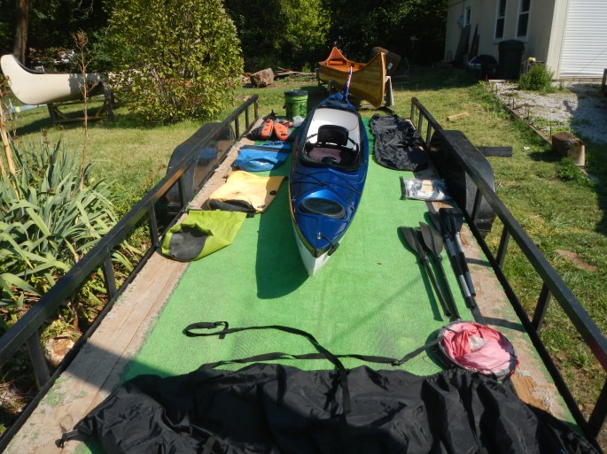
My daughter, Haley, and I are going to pick up my Shasta kayak tomorrow, December 16.  The boat and all the gear that came with the deal (thanks again, Bob!) is being stored at Michael Clark’s Big Muddy Adventures headquarters in St. Louis.  Merry Christmas to me (payment day is so far removed in the past that they will seem like gifts :))!  Thanks again Michael for storing the boat for me.

Boat and GearJPG

Also, Haley confirmed with me yesterday that she will help with my shuttle.  She will accompany me to Montana, and hang out with me until I get started.  Then, drive my car back home.Xmas_2011_MoRiver

(The bandage on my hand was from last year this time.  I had carpal tunnel surgery on both my hands.  They are great now.)  We’ll definitely stay at Norm Miller’s Base Camp International in Livingston, MT, while I try and assess whether a source start is feasible. This road trip will be the first time we have been out of the state together, or on any type of significant trip, ever.  I cannot wait!

Rod Wellington, who will be paddling through Cooper’s Landing this Monday and Tuesday, will help me get a better idea of what the 300 mile stretch from Brower’s Spring to Three Forks is like.  He is encouraging me to start at the source: “Janet, I wholly encourage you to start at the source. The 298 river miles above Three Forks was my favourite part of the river. it cannot be topped. ”  I have wanted to start at the source since I decided to do this trip.  However, April will offer up additional challenges.

snow at browers

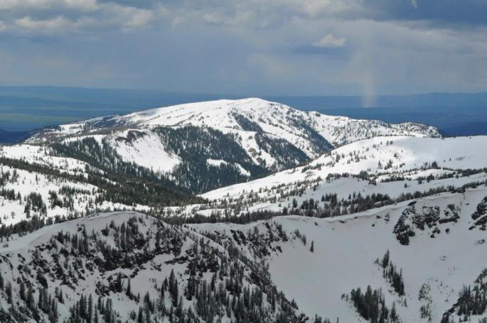
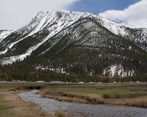
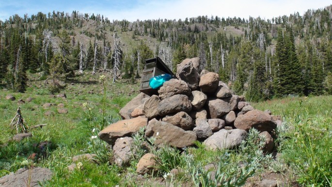
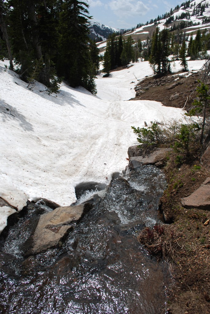
Brower’s Spring drainage heads off to the upper right of this photo (by Norm Miller).  This photo was taken in June.  I will have to start in mid-April.  Not sure if it will be possible, despite my ski-mountaineering background.  Hell Roaring Creek below heads downhill from the spring and, obviously, will not be a paddling stretch.  Seven miles hiking in and seven out.  Something to seriously consider.

HellRoaringCreek

I added a Pay Pal button on this blog (Make a Donation Page).  Financial support is not the only “support” I need, but it is an important one.  Haley and I met with Tina Casagrand yesterday to discuss Kickstarter, an online video fundraising program.  She shared a lot of valuable information with us in this regard.  I have asked Jim Karpowicz, friend, river rat, founder of Missouri River Relief, and creative documentary filmmaker, if he can help me produce a video.  He is willing to help so I hope to meet with him to discuss further.

I also met with the co-founder of Missouri River Relief, Charlotte Overby, who is now River Coordinator at Conservation Lands Foundation (CLF), and beloved by our entire river rat community.  CLF works with and supports groups and non-profits who advocate for wilderness lands managed by Bureau of Land Management (condensed explanation).  CLF supports Friends of the Missouri Breaks Monument.  We are floating ideas around.

UpperMoBreaks

I created a Facebook Page, LoveYourBigMuddy Expedition, so please “like” it.  Part of expedition planning is sponsorship proposals.  Companies like to see lots of exposure potential in their sponsorees.  Social media is a big component of the total experience.  Being as this is my first endeavor, it is likely sponsorship will be light, if not none.  But, one never knows for sure, right?  If you are reading this and have not yet “liked” my FB page, I implore you to do so.

Rod Wellington is due to arrive at Cooper’s Landing Monday and stay over a couple of nights.  He started at the source in June, and is paddling to the Gulf of Mexico.  He is paddling the seven longest rivers in seven continents, all self-powered.

Rod Wellington

We will take good care of Rod at Cooper’s, as we do all of the river folk paddling through.  He can stay for free, take a shower, do his laundry, drink beer, play games, eat a home-cooked meal, run into town, and watch wide-screen surround sound sports/TV/movies.  Monday night is game night at Cooper’s. Yes, like games:  SkipBo, Monopoly, Cribbage, darts, etc.   May be a bit of culture shock.  Although, he’ll be hanging out with river folk family.  We’ll warm him up before sending him back out on the river. Robin and Connie Kalthoff in Waverly set a high bar for taking care of paddlers.  They are about 3 or 4 days upriver, and one of the stops for paddlers on the way; a hard act to follow.  Here they are just yesterday, Friday.

Robin Kalthoff

Rod and I will be discussing the 300 miles between the source and Three Forks quite a bit.

You can visit his website at ZeroEmissionsExpedition

Zero Emissions Expeditions passionately promotes the practice of low impact, long distance, self-powered exploration.

Oh, one other thing happened last week.  I spoke with my Social Studies methods professor when he was writing up a teaching letter of recommendation for me.  I directed him to the MizzouWire story, which had just posted a couple days earlier.  Then I brought him to my blog site, and he loved all of it, especially the book, “Our Mississippi.”  He asked me to contact him after break and said he would help me with a book.  We’ll see.  I love it when things just fall into place.

Thanks for listening.  -Janet

Let’s see, where do I begin?

Below Three Forks (photo by Norm Miller)

Okay, where do I begin?

Do I start at the Missouri River’s source, Brower’s Spring, or do I start at the Missouri River’s mouth, Three Forks, where the Jefferson, Madison, and Gallatin Rivers merge to become the mighty Missouri?  Approximately 300 miles separates the ultimate source and the river’s official mouth, and about 10-12 days of paddling.  At one time, with all due ignorance, I pictured that 300 miles to be pristine Montana wilderness, kayaking through isolated Rocky Mountain Wilderness on a sweeping clear water creek, just me, the mountains, and the wildlife.  Not so, I have learned.  Here is Mark Kalch’s account of paddling from the source at Brower’s Spring to Three Forks:

The Red Rock River issues forth from the lake and winds endlessly and listlessly out of the valley. Snaking back on itself time after time with negligible flow meant forward movement out of the area was slow. A coyote wandered to the river’s edge to investigate my kayak and I. His boldness surprised me. Cattle followed me along the river’s meander. Slowly, slowly I carried on.

On to Lima Reservoir the wind picked up and forced an early camp. Overnight my tent was buffeted by its strength. Across the still body of water and a short portage later I once more hit river. Now things hit up a gear. The river, narrow, shallow but running super fast was an interesting encounter. Trees fallen in the water loomed as sweepers and strainers. Turning a 17 foot kayak on a fast corner in an 18 foot wide river takes some doing. Soon man made his presence felt. Fences, of barbed wire and electric lurked in possibility around every corner. Out of my boat, dragging under the lower wire, submerging myself in the icy water, back on board and away again. Repeat for days at a time.

The river finally spewed onto Clark Canyon Reservoir, much to my relief. Another crossing and dam portage on to the Beaverhead River. Now wider, flowing fast, this river looked the part. Appropriately, fisherman now lined it’s banks in drift boats and suited in waders. A quick heads up alerted them to my presence. Non-plussed about my appearance the immediately returned to their labour. Just one guide questioned me – “You headed to New Orleans?”. My reply had him genuinely stoked!

The Beaverhead wound it’s way to Dillon and on to the small town of Twin Bridges. At times beautiful and peaceful, at others endless ranches, cattle and excrement runoff. But it was all about to change. 20 minutes paddling beyond Twin Bridges, the Big Hole River enters from river left. Behold, the formation of the Jefferson! Truly, one of the most beautiful paddling experiences I have ever had. If only the past week could have been so. The river, lined with forest, the water running deep and swift. Now this is a river journey. Alas, it was over all to quickly. In no time with a final hard push I approached the town of Three Forks. A few miles beyond the Madison joins the Jefferson from river right. A few minutes later, the Gallatin as well. A hundred feet beyond, a boat ramp and now this river which issued forth from a snow choked spring had finally become the mighty Missouri! The first, difficult, demanding and ultimately tiny stage of my river descent was complete. With a root beer in one hand and pizza in the other I was tired but happy. Time for a resupply and washing of muddy clothes. In a couple of days it is back on the water and to the sea I go. I am ready.

This is Mark Kalch just below Three Forks (photo by Norm Miller).  I think this looks like a fine place to start.  Yep.

Mark is paddling seven rivers on sever continents.  You can follow his adventure here:

http://www.7rivers7continents.com/lake-it-or-not/

Rod Wellington is also paddling seven rivers on seven continents.  You can follow him on his Facebook page here:

https://www.facebook.com/rod.wellington.9

And, Bob Bellingham is paddling from Three Forks to St. Louis and will be passing through Cooper’s Landing in about a week.  You bet I’m going to pick his brain.  He knows.  You can follow his blog here:

http://www.steadypaddling.com/

Then again, Norm Miller got me thinking about a bike/hike to the town of Dillon, then put in.  I understand the Jefferson River below Twin Bridges is gorgeous.  sigh…