We were getting tired by the afternoon and frustrated with the terrain traps we encountered, which kept adding miles on to our trip. Here is a short clip Norm took after my, umm, classic faceplant.
Shortly after the faceplant, we realized we were not going to make it out. Fortunately, our walkie-talkies were able to reach Haley and Jeannie just for a moment, and we notified them we would be staying overnight. We tried not to seem alarmed so they would not worry. That worked. We did the same for ourselves, and just tried to make the best of the situation.
The first thing we needed to do to get the Brower’s Spring was to get throught the Federal Aviation Administration gate that guards the road up Sawtelle Peak. We needed to ske from one of the switchbacks over to Jefferson Peak and up and over the Continental Divide into the Hell Roaring Creek Drainage where the spring is located.
Curt Judy unlocked the gate for us so we could ski over to Jefferson Peak from the road switchback. Thanks, Curt!Mount Jefferson from on top of the bowl.
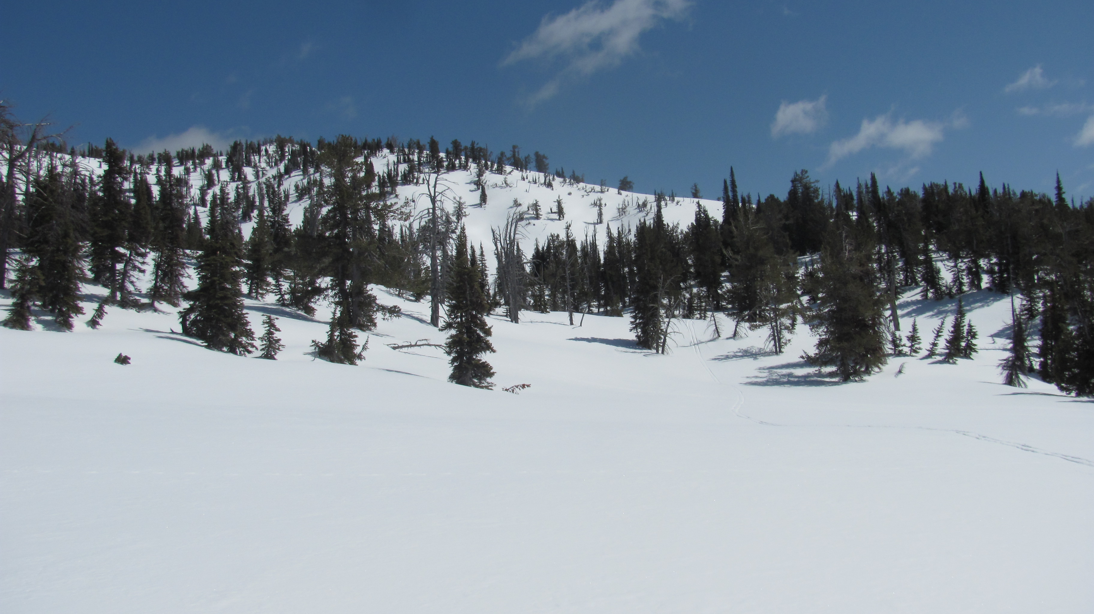
This is the top of Mount Jefferson which stands at 10,200 ft. We traversed the top of the bowl and dropped into the Hell Roaring Creek drainage off to the left. This was a spectacular moment in the ski.
You can see the Teton Range from on top.Sometime at the beginning of our ski in to the spring.Your can see the triangle where I am standing and the push pin where the spring coordinates are, almost touching.
GPS showed me I was soooooo close to the spring. The surroundings indicated to me that I was likely standing on or near the spring. I could feel it in my heart and soul. My heart was racing and I was excited.
Brower’s Spring just inside the trees in center of photo.
I skied out of those trees where I am sure I was on or near the spring. Rod Wellington, who has also been there, confirmed that the area looked familiar to him.
We even got some turns in. Unfortunately, no photos of our figure eights. Darn!
We assumed that the trip would entail an easy seven-mile ski out of Hell Roaring Canyon. We were mistaken. Because of the snow cover, we needed to be cautious of avalanche danger, and often fell prey to terrain traps, which produced steep drop-offs, false canyons, and unskiable gulleys. Because of this, we were destined to stay over night, which neither of us prepared for. In fact, we absent-mindedly left the car with no means of fire or sleeping gear. We were both tense until we gave in to the fact we were staying the night. Then, our priority switched to surviving the night. We never doubted our ability to do so.
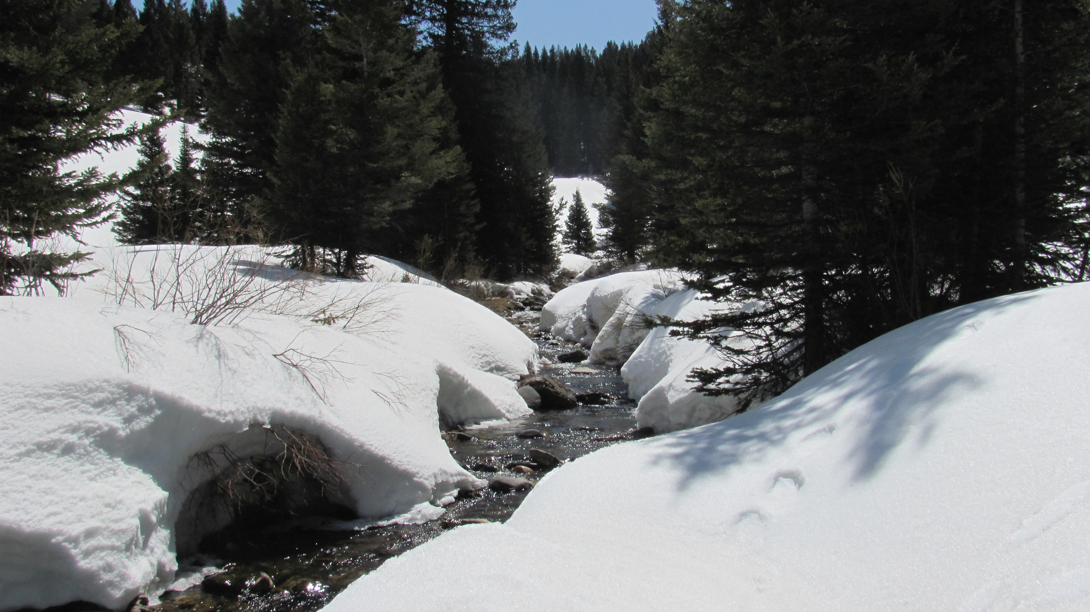
We were at the top of that distant ridge at one point. You could see the Sawtoothe Range in Idaho. We had to be vigilant about avalanche danger.Norm getting water from Hell Roaring Creek. At this point we knew we were sleeping in the mountains.Norm building the shelter. We both took part in this important project.The PBR Haley threw in our pack. Happy we had the extra calories before a long cold night.
I shivered uncontrollably all night. I was only able to sleep for about five minutes. Norm was the same way. Somehow, the hours past and it was time to go. I am thankful to have survived and avoided hypothermia. I had trailmix to eat and a granola bar which we split. I had to eat one of the granola bars for calories just after going to bed. Perhaps, it helped, I could not tell.
Beautiful full moon night, despite the situation.Hell Roaring CreekWe skied 12 miles instead of 7 because of terrain traps that forced us to back up and go another way.Grizzly tracks. We made ourselves known by talking at the bear for the last couple hours of our ski.The end finally in sight. And, so were the bear tracks, which came up from the valley where Haley and Jeannie were sleeping in the car.Haley and Jeannie, support crew, waiting patiently for us. We had minimal contact with walkie talkies that we brought, so we were able to notify them of our overnight stay.Here is the grizzly track Haley took a photo of at the base of Hell Roaring Canyon, where we came out.Oh my God, we did it! Good job!
Next came the bike ride, 90-some miles from the base of Hell Roaring Canyon to Clark Canyon Dam. The ride took three days. The ride of all rides, the vistas were spectacular.
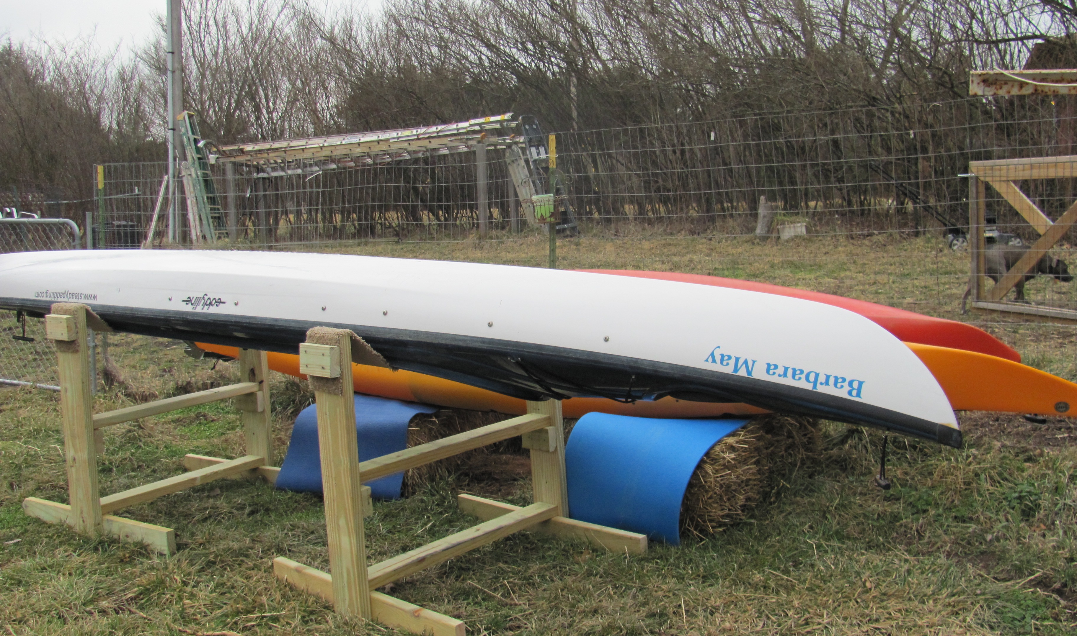
Enjoying four days off from substitute teaching this week-end. Friday was a teacher work day and Monday is Presidents’ Day, a holiday. Lots to do, lots to do. First thing to tend to is my boat.
The old keel strip has been removed. I just need to wipe it down and get all the goo off of it. Eddyline Kayaks will walk me through applying the new strip. It is a protective strip that keeps the bottom from getting too banged up when exiting the water onto shore. Hopefully, rocks will not be too big an issue on the trip.
I will also get the rudder hooked up with the cables, remove the old name, “Barbara May” and change to “Blue Moon.” I mean, how often does a trip like this cross your path? You got it: once in a blue moon. The next blue moon is in 2015, I believe. Anyway, I will also remove Bob Bellingham’s web site address, steadypaddling.com, and apply my own, http://www.loveyourbigmuddy.com. I think I will be ready for my maiden cruise after that.
Time for a name change.
The video is ready except for one last little edit. I may be able to post it here by the time I’m finished writing this post. Facebook is very easy to post things on quickly, but my blog is like home base. We’ve been together for quite a while now, growing together, so I’d like to post the video here first. It is short and sweet.
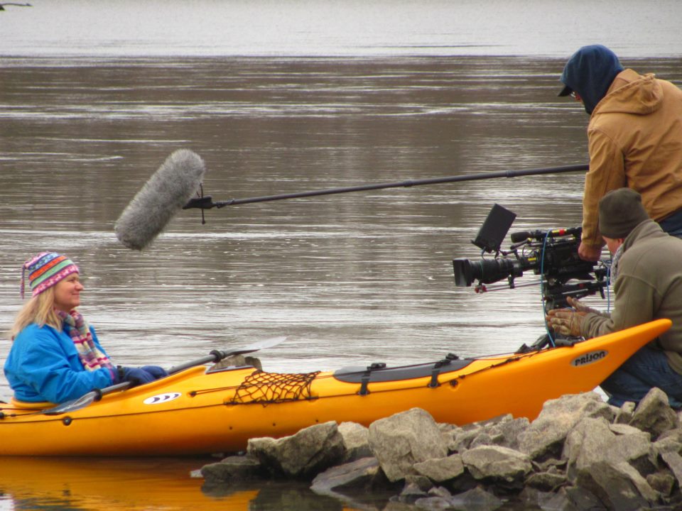
Making the video. (Photo by Dennis Dye)
I will be starting a fundraising page with GoFundMe. I have been fighting the idea in my mind, whether or not to go “commercial.” I guess I will go for it, since I really do need the financial support. Substitute teaching is wonderful, but the pay is meager. I love the fact that many of my friends are donating on my “Donation Opportunities” blog page. Warms my heart and builds me up.
Here is one of Norm Miller’s re-supply packs from his trip UP the Missouri River in 2004.
I will soon start my food supply list, get detailed on what clothing items I will bring, and take another day to invite companies to donate items. I feel as though the bigger companies are not interested since this is my first expedition. I am trying not to depend on their support. If fundraising goes well, I will purchase the items I need such as a tent, down sleeping bag, stove, GPS device, etc.
I visited with our local sport shop businesses in Columbia last week. The effort is proving to be beneficial. Walt’s Bicycle Fitness Wilderness will be donating a couple of items from my wish list. And, I am pretty sure Klunk Bicycles is donating a used mountain bike for the portion of my trip requiring a bike ride due to frozen waterways. Once officially donated, I will make an announcement. I really want to help promote our local businesses if I can.
I am watching the snow depth level at Lakeview very closely now. The first stretch of my trip will be determined by the winter conditions such as snow and ice-covered lakes and rivers. This link gives historic as well as daily snow levels and water input into the Red Rock River.
South Valley road in winter is often only passable using a snowmobile. This is looking east into the refuge. Lakeview is in the distance. Photo taken in Feb., 2011 (I think). (photo by James N. Perdue)
I am determined to get to Brower’s Spring no matter how much snow has fallen. I will have to rely on my ski mountaineering experience from my years living in the Sierra Nevada Mountains. Staying strong and healthy until April is very important. I am running two miles every other day, rowing on the rowing machine, taking walks, and will soon start riding my mountain bike substantial distances. I always try to eat good and wholesome foods. Basically, high fiber and low fat is my norm. I have made the switch to 100% whole wheat breads and pasta, and I eat a green salad just about every night. I will miss having a glass of Chardonnay with dinner while on my trip. Maybe I can stowaway a bottle now and then.
I have topped the 200 “likes” number on my Facebook page. YaY! If you have not liked the page, please do so. As I mentioned before, I am able to post to FB much more than I do blog posts. These posts take time and careful consideration, which I am finding harder to do now that I am substitute teaching most days.
The Columbia Missourian, University of Missouri’s Journalism School newspaper, interviewed me last week and we will meet soon for a photo shoot. The Missourian produced the first piece of media about my trip way back last August (or September?), with Bob Bellingham’s paddle down the Missouri River being the main feature. You can find that article on my “Media” page. Now, my trip will be a feature article. I am happy about having our local press support my trip. Here is Ciera, the journalism student who interviewed me. She is just delightful.
I started a Twitter account, @MoRivExpedition, so that I can utilize all the social media tools. I really don’t know much about Twitter. I am learning as I go. I am following a lot of cool adventure people, but only have two followers. That’s okay, though. I have no idea how to accumulate followers. I will just tweet little tweets now and then, and see how things progress. Once I get started on my trip, I cannot imagine having time to keep up with all the social media anyway. I will have to save my writing for the rainy days…or, snowy days…or, windy days.
Or, maybe on an occasional lovely day, I will take a break and hang out.
…Woke up midnight last night and imagined Brower’s Spring with perfect spring corn snow skiing conditions in April, which is when we used to ski peaks on the east side of the Sierra Nevada Mts in the 80’s. I broke out into a huge smile. Then, repeating over and over, “pray, believe…pray, believe…”, I drifted back to sleep.
I will be starting at the source. That’s it. No more wavering.
My stickers are in the mail. I modified them by changing the color to blue, from black, and the miles to 2600, from 2300.
Met with Jim Karpowicz today and we are on the move to create a promo video in order to generate some wide-reaching support and, hopefully, funding. It’s going to be great!
If you haven’t already, please “like” my loveyourbigmuddy Facebook page. I can post little updates there with a bit more spontaneity.
Starting at the source of the Missouri River will entail getting to Brower’s Spring, which is at the top of Hell Roaring Canyon. From the bottom of the canyon (left-center) the hike is seven miles in and seven out, over SNOW in April. If Sawtelle Peak access road is plowed (doubtful) in April (right), the ski over is only a couple of miles along the Continental Divide, then down the canyon. I see ski-mountaineering revisiting my life this spring. Breaking out the 3-pin bindings!