Canadian Paddler Rod Wellington & a MO Riv Source Start

Rod-photo_Coops_12-18-2012
Photo by Rod Wellington

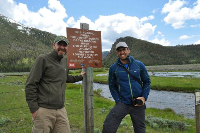
Canadian paddler Rod Wellington passed through Cooper’s Landing last Monday and Tuesday, Dec 17-18.  He is paddling from the source of the Missouri River at Brower’s Spring, MT, to the Gulf of Mexico, all self-propelled.  This is the longest river system in North America, and fourth longest in the world.  Rod will be the first Canadian to paddle the MO from source to sea.  Australian paddler Mark Kalch completed the route earlier this year.

Norm Miller (left) and Mark Kalch (right) at Hell Roaring Creek in June 2012

Altogether, Rod will paddle seven of the longest rivers on seven different continents.  The Missouri River is his first.  He has been on the river since June, a total of six months.  His river systems project could take up to 15 years.

Photo by Rod Wellington

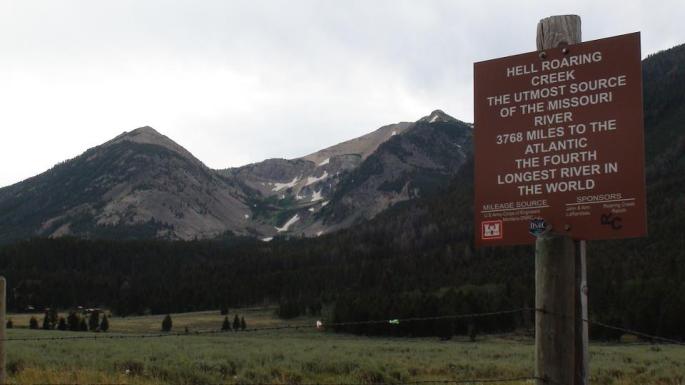
After a pot luck dinner and visiting with many interested locals, he graciously sat with me and poured over photos and a map from the Brower’s Spring area, the Missouri River source, to Three Forks, the headwaters of the MO Riv, a 298 miles stretch and one in which I am debating whether to include on my trip.

MAP_Browers-ThreeForks-USA

MAP_Browers-ThreeForks_flip

Browers-August
Cairn at Brower’s Spring with Continental Divide behind. Photo taken in August 2011 while scouting the source (photo by Rod Wellington)
Continental Divide at Brower's Spring in June 2012-by Rod Wellington
Continental Divide at Brower’s Spring in June 2012 (photo by Rod Wellington)
Looking down from the spring in June 2012.  Undoubtedly, April will have a LOT more snow. -by Rod Wellington
Looking down from the spring in June 2012. Undoubtedly, April will have a LOT more snow. (photo by Rod Wellington)

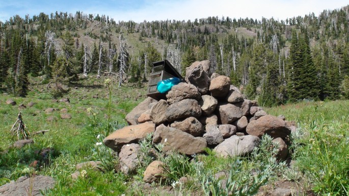
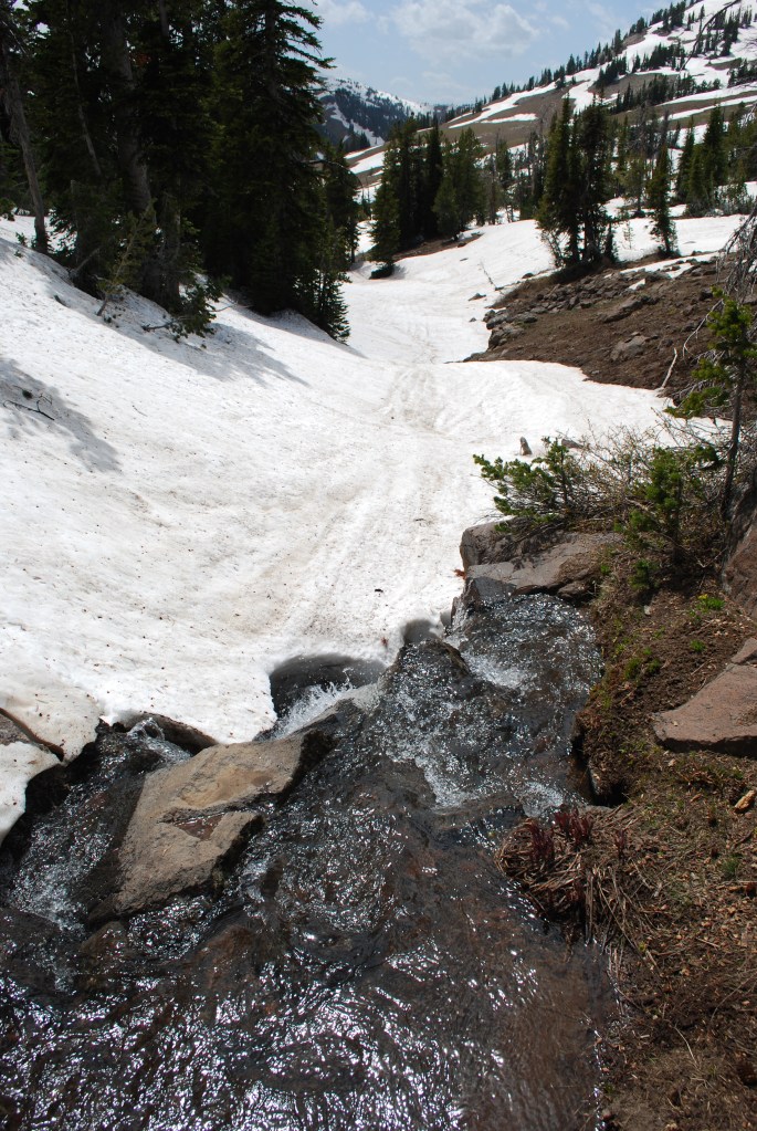
No firm decisions yet as there are a few dicey stretches, like hiking/skiing/snowshoeing over snow for seven miles into Brower’s Spring, and seven miles out.  And, a few days of dodging and portaging around farmers’ barbed wire/electrical/corrugated panel fences which cross a mere 20′ wide water way below the Lima Reservoir on the Red Rock River.  Not to mention that the Red Rock Lakes Wildlife Refuge, located above the Lima Reservoir, is closed in April.

At least now I have a greater understanding of what my obstacles and options are.  I have an unrelenting desire to capture some of that 298-mile stretch for its sheer beauty.  Some of it may have to be biked.  Thanks, Rod, for spending that time with me.

Jefferson River below Twin Bridges
Jefferson River below Twin Bridges (photo by Norm Miller)
Deer on Jefferson River (photo by Norm Miller)
Rain approaching Jefferson River (photo by Norm Miller)

Understandably, Rod needed to leave Cooper’s Landing and continue

Rod and Jonathan at Cooper's Landing.
Rod and Jonathan at Cooper’s Landing. Notice the wood-carved hawk that is Jonathan’s handiwork.

paddling towards the Gulf of Mexico.  However, our first major storm

of the season hit yesterday, the day after he left.  Winds gusted to 50 or 60 mph, and snow was blizzard-like.  One caring and supportive local, Jonathan Lauten, set out to find Rod and make sure he was okay.  He found him across the river below Jefferson City, but was not able to make contact.  We learned that Rod was hunkered down in his tent, warm and dry.

Rod laying low in a miserably cold, windy, and snowy storm. -by Jonathan Lauten
Rod laying low in a miserably cold, very windy, and snowy storm (you can see the wind plowing into the side of his tent). (photo by Jonathan Lauten)

Jonathan’s comment from Facebook:

I found him, but I couldn’t get to him!
This pic was taken from a bluff across the river 4:00 12/20/12.
Of course, it was hard to pick him out amongst all those other campers on the Missouri River in a blizzard with 50 mph winds…

Here is a post from Rod yesterday morning, much to our relief:

Dec. 20, 10am – Currently hunkered down in my tent on a sandbar near Jefferson City, Missouri. Outside: blowing snow, sustained winds of 35-40 mph with gusts of 50 mph or more. Unable to keep tent and tent fly anchored. I’ve arranged heaviest gear on windy side of tent to act as a buffer. I’m warm and dry. No paddling today. Expected low tonight: 5F with windchill. Thanks to Steve Schnarr, Gary Leabman, Robin Kalthoff and Jessica Giard for checking on me via phone. Still smiling!

Great meeting Rod and spending some time together.  I think I speak for lots of other folks who met him as well.

Rod and me -photo by Jonathan Lauten
Rod and me (photo by Jonathan Lauten)

You can read posts and watch videos from his trip thus far, and track his current progress on his FB page: “Rod Wellington.”

Happy paddling!

Let’s see, where do I begin?

Below Three Forks (photo by Norm Miller)

Okay, where do I begin?

Do I start at the Missouri River’s source, Brower’s Spring, or do I start at the Missouri River’s mouth, Three Forks, where the Jefferson, Madison, and Gallatin Rivers merge to become the mighty Missouri?  Approximately 300 miles separates the ultimate source and the river’s official mouth, and about 10-12 days of paddling.  At one time, with all due ignorance, I pictured that 300 miles to be pristine Montana wilderness, kayaking through isolated Rocky Mountain Wilderness on a sweeping clear water creek, just me, the mountains, and the wildlife.  Not so, I have learned.  Here is Mark Kalch’s account of paddling from the source at Brower’s Spring to Three Forks:

The Red Rock River issues forth from the lake and winds endlessly and listlessly out of the valley. Snaking back on itself time after time with negligible flow meant forward movement out of the area was slow. A coyote wandered to the river’s edge to investigate my kayak and I. His boldness surprised me. Cattle followed me along the river’s meander. Slowly, slowly I carried on.

On to Lima Reservoir the wind picked up and forced an early camp. Overnight my tent was buffeted by its strength. Across the still body of water and a short portage later I once more hit river. Now things hit up a gear. The river, narrow, shallow but running super fast was an interesting encounter. Trees fallen in the water loomed as sweepers and strainers. Turning a 17 foot kayak on a fast corner in an 18 foot wide river takes some doing. Soon man made his presence felt. Fences, of barbed wire and electric lurked in possibility around every corner. Out of my boat, dragging under the lower wire, submerging myself in the icy water, back on board and away again. Repeat for days at a time.

The river finally spewed onto Clark Canyon Reservoir, much to my relief. Another crossing and dam portage on to the Beaverhead River. Now wider, flowing fast, this river looked the part. Appropriately, fisherman now lined it’s banks in drift boats and suited in waders. A quick heads up alerted them to my presence. Non-plussed about my appearance the immediately returned to their labour. Just one guide questioned me – “You headed to New Orleans?”. My reply had him genuinely stoked!

The Beaverhead wound it’s way to Dillon and on to the small town of Twin Bridges. At times beautiful and peaceful, at others endless ranches, cattle and excrement runoff. But it was all about to change. 20 minutes paddling beyond Twin Bridges, the Big Hole River enters from river left. Behold, the formation of the Jefferson! Truly, one of the most beautiful paddling experiences I have ever had. If only the past week could have been so. The river, lined with forest, the water running deep and swift. Now this is a river journey. Alas, it was over all to quickly. In no time with a final hard push I approached the town of Three Forks. A few miles beyond the Madison joins the Jefferson from river right. A few minutes later, the Gallatin as well. A hundred feet beyond, a boat ramp and now this river which issued forth from a snow choked spring had finally become the mighty Missouri! The first, difficult, demanding and ultimately tiny stage of my river descent was complete. With a root beer in one hand and pizza in the other I was tired but happy. Time for a resupply and washing of muddy clothes. In a couple of days it is back on the water and to the sea I go. I am ready.

This is Mark Kalch just below Three Forks (photo by Norm Miller).  I think this looks like a fine place to start.  Yep.

Mark is paddling seven rivers on sever continents.  You can follow his adventure here:

http://www.7rivers7continents.com/lake-it-or-not/

Rod Wellington is also paddling seven rivers on seven continents.  You can follow him on his Facebook page here:

https://www.facebook.com/rod.wellington.9

And, Bob Bellingham is paddling from Three Forks to St. Louis and will be passing through Cooper’s Landing in about a week.  You bet I’m going to pick his brain.  He knows.  You can follow his blog here:

http://www.steadypaddling.com/

Then again, Norm Miller got me thinking about a bike/hike to the town of Dillon, then put in.  I understand the Jefferson River below Twin Bridges is gorgeous.  sigh…